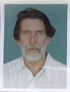
Dr. Bruno Marcolongo is a geo-archaeologist and author of international renown, currently Director of Research Unit at the National Research Council of Italy/Institute of Applied Geology in Padua. Also Visiting Professor of Remote Sensing in Earth Sciences at a number of Italian universities, he has academic association with VAIS as well, heading Environment/Remote Sensing Research in its “Kampilya Project”. And shares the distinction of being one of the discoverers of Drupad Kila. As an expert for the European Commission/Joint Research Centre of Ispra in various European environmental projects, he extablished durable.collaborations with French CNRS (Scientific Research National Centre) in Paris and Russian Academy of Sciences in Moscow – besides his expert involvement in many geo-archaeological missions in Near- Middle East and Central Asia.
Honorary Diploma of Academician (no. 12 granted by Mongolian Academy of Sciences in Ulaanbaater on 31st August 2007).
Honorary Diploma in Archaeology (conferred by the Institute of Archaeology of the Mongolian Academy of Sciences in Ulaanbaatar on December 2008).
Since 1996 Member of the board of governors of “Venetian Academy of Indian Studies”
(V.A.I.S.), University “Ca Foscari”/ Dip.of Asian and Far East Studies.
Since 1996 President of the V.A.I.S. section of Padova.
1994-1996 Head co-ordinator of the feasibility study on “Exploitation of new satellite sensors in the detection of orchards: test site of Verona plain” contract [n°]. 10451-94-09 F1ED ISP F of the European Commission/ CCR, Ispra.
1988-1992 Member expert of the Technical Scientific Committee “Spatial Technology and Land Management” of the Department for the South Italy/ Ministry for the Extraordinary Interventions in the South Italy.
1986-1992 Member founder and official representative for Italy of the “Reseau Europeen: Teledetection Archeologie [et],” constituted under the high patronage of Council of Europe and European Commission, Bruxelles.
1985-1992 President and member founder of the Environmental Researches Center “Athesia,” for naturalistic, palaeo-ethnological, environmental and historical studies in the Venetian plain, University-Cnr, Padova.
1979-1982 Member expert of the “Technical Scientific Commitee on Applications of Remote Sensing in Agriculture and Hydrology”, Ministry of the Agriculture and Forests.
1978-1981 “Principal Co-Investigator” for NASA and European Commission CCR/ Ispra on “Applications of satellite thermal images in hydrology and hydrogeology,” in the ambit of the International Project “Tellus.”
1978-1979 Head co-ordinator of the study on “Applications of Remote Sensing to the identification, evaluation and management of the principal European ground-water systems” contract [n°] 848-78-01 SISPI of the European Commission CCR, Ispra.
1976-1978 Expert for European Commission/CCR, Ispra, in a feasibility study on “Remote Sensing utilisation to establish an European olive-trees cadaster”. The methodology defined by the writer has been officially applied by ITA Consortium (Italeco-Telespazio-Aquater), commissioned by the Ministry of the Agriculture and Forests of Italy for the whole Italian cadaster since 1981.
1978-1982 Member founder and Member of the Board of Governors of the Italian Remote Sensing Society (S.I.Te.).
| There are no products |